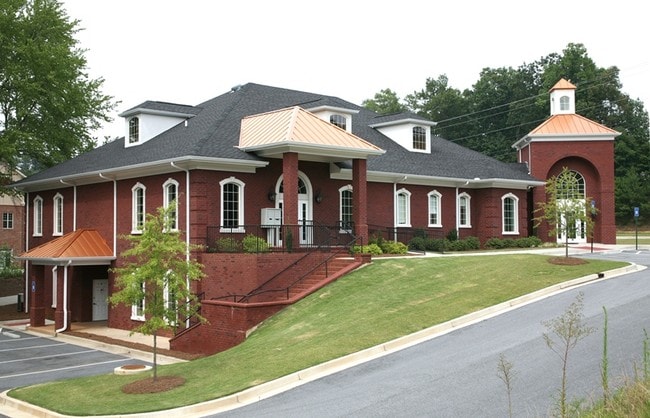
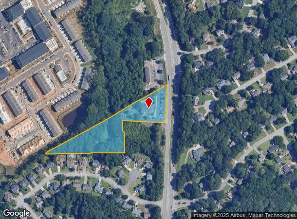
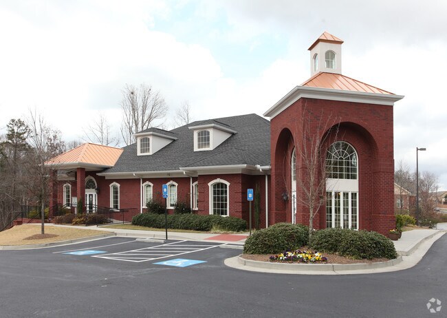
Property Record
2566 Lawrenceville Suwanee Rd, Suwanee, GA 30024
NEARBY LISTINGS FOR SALE OR LEASE
Property Detail
2566 Lawrenceville Suwanee Rd
7-127-475
Suwanee Rd
Medicalbuilding
LVILLE SUWANEE RD
X
Gwinnett
13135C0044F
Georgia
2025
2.76 AC
2025
Duluth/Suwanee/Buford
050529
Atlanta
9,909 SF
Atlanta-Sandy Springs-Roswell, GA
DEMOGRAPHICS near 2566 Lawrenceville Suwanee Rd
1 Mile
3 Mile
5 Mile
2024 Total Population
7,058
67,301
185,739
2029 Population
7,307
70,113
194,292
Pop Growth 2024-2029
+ 3.53%
+ 4.18%
+ 4.60%
Average Age
38
39
38
2024 Total Households
2,368
22,487
63,840
HH Growth 2024-2029
+ 3.59%
+ 4.35%
+ 4.76%
Median Household Inc
$93,328
$98,148
$85,869
Avg Household Size
3.00
2.90
2.90
2024 Avg HH Vehicles
2.00
2.00
2.00
Median Home Value
$287,104
$324,513
$337,173
Median Year Built
1991
1995
1997
Nearby Places
Map Layers
Map Styles
 Street
 Aerial
- Restaurants
- Banks
- Shops
- Fitness
- Groceries
PUBLIC TRANSPORTATION
AIRPORT
Hartsfield - Jackson Atlanta International
DRIVE
WALK
Distance
Hartsfield - Jackson Atlanta International
53 min
40.6 mi
SALE & LEASE HISTORY
LISTING DATE
SALE/LEASE

Jun 06, 2023
For Sale
Nearby Properties
Address
Land Use
TOTAL SIZE
Lot Size
Zoning
Address
Land Use
TOTAL SIZE
Lot Size
Zoning
482,658 SF
17.05 AC
MUR
Address
Land Use
TOTAL SIZE
Lot Size
Zoning
404,176 SF
32.67 AC
M2
Address
Land Use
TOTAL SIZE
Lot Size
Zoning
415,963 SF
48.86 AC
RM10
Address
Land Use
TOTAL SIZE
Lot Size
Zoning
280,454 SF
19.97 AC
MUR
Address
Land Use
TOTAL SIZE
Lot Size
Zoning
471,807 SF
69.50 AC
R100
Address
Land Use
TOTAL SIZE
Lot Size
Zoning
379,183 SF
6.09 AC
PMUD
Address
Land Use
TOTAL SIZE
Lot Size
Zoning
304,276 SF
14.90 AC
MUR
Address
Land Use
TOTAL SIZE
Lot Size
Zoning
439,723 SF
64.56 AC
R100
Address
Land Use
TOTAL SIZE
Lot Size
Zoning
428,329 SF
18.44 AC
RM24
Address
Land Use
TOTAL SIZE
Lot Size
Zoning
220,779 SF
7.32 AC
PMUD
Address
Land Use
TOTAL SIZE
Lot Size
Zoning
287,187 SF
9.96 AC
RM24
Address
Land Use
TOTAL SIZE
Lot Size
Zoning
514,956 SF
47.21 AC
M1
Address
Land Use
TOTAL SIZE
Lot Size
Zoning
248,400 SF
13.92 AC
MUO
Address
Land Use
TOTAL SIZE
Lot Size
Zoning
385,167 SF
49.55 AC
M1
Address
Land Use
TOTAL SIZE
Lot Size
Zoning
503,650 SF
34.37 AC
M1
Address
Land Use
TOTAL SIZE
Lot Size
Zoning
332,011 SF
8.84 AC
PMUD
Address
Land Use
TOTAL SIZE
Lot Size
Zoning
6,552 SF
235.95 AC
R140
Address
Land Use
TOTAL SIZE
Lot Size
Zoning
661,663 SF
50.64 AC
M1
Address
Land Use
TOTAL SIZE
Lot Size
Zoning
327,360 SF
26.42 AC
M1
Address
Land Use
TOTAL SIZE
Lot Size
Zoning
457,110 SF
22.37 AC
M1
Address
Land Use
TOTAL SIZE
Lot Size
Zoning
553,941 SF
32.82 AC
M1
Address
Land Use
TOTAL SIZE
Lot Size
Zoning
6,031 SF
120.86 AC
OI
Address
Land Use
TOTAL SIZE
Lot Size
Zoning
597,445 SF
39 AC
M1
Address
Land Use
TOTAL SIZE
Lot Size
Zoning
595,760 SF
39.11 AC
M1
Address
Land Use
TOTAL SIZE
Lot Size
Zoning
541,840 SF
29.37 AC
M1
Address
Land Use
TOTAL SIZE
Lot Size
Zoning
160,021 SF
14.27 AC
PMUD
Address
Land Use
TOTAL SIZE
Lot Size
Zoning
310,168 SF
46.14 AC
R75
Address
Land Use
TOTAL SIZE
Lot Size
Zoning
195,706 SF
11.63 AC
OI
Address
Land Use
TOTAL SIZE
Lot Size
Zoning
235,807 SF
1.90 AC
M1
Address
Land Use
TOTAL SIZE
Lot Size
Zoning
175,613 SF
17.63 AC
M1
The World's #1 Commercial Real Estate Marketplace
Connect with us
© 2026 CoStar Group
The information above has been obtained from sources believed reliable. While we do not doubt its accuracy we have not verified it and make no guarantee, warranty or representation about it. It is your responsibility to independently confirm its accuracy and completeness. Any projections, opinions, assumptions, or estimates used are for example only and do not represent the current or future performance of the property. The value of this transaction to you depends on tax and other factors which should be evaluated by your tax, financial, and legal advisors. You and your advisors should conduct a careful, independent investigation of the property to determine to your satisfaction the suitability of the property for your needs.